Trail Walking Le Valtin - Col de la Schlucht - sentier des Roches - Petit Honneck - Honneck - Trois Fours - Photo

Col de la Schlucht - sentier des Roches - Petit Honneck - Honneck - Trois Fours

 Bart2015
Bart2015

User

© OpenStreetMap contributors
Length
Length
13.5 km
Max alt
Max alt
1355 m
Uphill gradient
Uphill gradient
599 m
Km-Effort
Km-Effort  
21 km
Min alt
Min alt
961 m
Downhill gradient
Downhill gradient
598 m
Boucle
Boucle
Yes
Creation date :
2020-09-07 11:47:34.114
Updated on :
2020-09-14 14:48:55.602

(2 Reviews)

Walking
Walking
3h40
Difficulty : Medium

Scan this QR Code to open this trail in the SityTrail application

FREE GPS app for hiking

Logo SityTrail SityTrail

IGN / Geographical institutes

Download SityTrail from the App Store Download SityTrail from Google Play

Logo SityTrail SityTrail World

The world is yours!

Download SityTrail from the App Store Download SityTrail from Google Play Download SityTrail on Huawei AppGallery

About

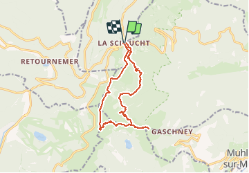
Trail Walking of 13.5 km to be discovered at Grand Est, Vosges, Le Valtin. This trail is proposed by Bart2015.

Description

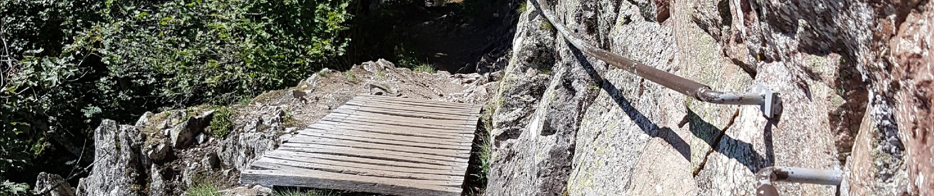
La randonnée démarre par le sentier des Roches, une des randos les plus difficiles des Vosges. Pied sûr, insensibilité au vertige, bonnes chaussures et conditions climatiques adéquates conseillés. Passage par la grotte Dagobert et son histoire avant de rejoindre le sommet du Hohneck avec ses vues magnifiques sur les sommets alentours ainsi que sur le lac du Schiessrothried. Une halte s'impose ...
Bonne randonnée.

Elevation profile

Photos

76 photos in total. Please click on a photo to see them all in the gallery.

Positioning

Country:
France
Region :
Grand Est
Department/Province :
Vosges
Municipality :
Le Valtin
Location:
Unknown
Start:(UTM)
352694 ; 5325256 (32U) N.

Comments

Please log in to post a review or rate the element


Trails nearby

Trail Walking Stosswihr - Tour du belvedere avec le passage sur les crêtes  - Photo
Walking
ocepee

Walking

Very easy
(2)
Stosswihr, Grand Est, Haut-Rhin, France
8.5 km | 0 m-effort
2h 28min
Yes
Trail Other activity Soultzeren - Totom 4 lacs - Photo
Other activity
dinozore

Other activity

Medium
(1)
Soultzeren, Grand Est, Haut-Rhin, France
15.6 km | 26 km-effort
4h 37min
Yes
Trail Walking La Bresse - Les 5 lacs autour du Hohneck - Photo
Walking
tiene

Walking

Very difficult
(1)
La Bresse, Grand Est, Vosges, France
21 km | 36 km-effort
7h 21min
Yes
Trail Walking Le Valtin - Les Hirschsteine - Photo
Walking
VacheKiri67

Walking

Difficult
(1)
Le Valtin, Grand Est, Vosges, France
16.1 km | 25 km-effort
6h 28min
Yes
Trail Walking Ban-sur-Meurthe-Clefcy - La vallée de Belbriette - Ban-sur-Meurthe-Clefcy - Photo
Walking
tracegps

Walking

Medium
(2)
Ban-sur-Meurthe-Clefcy, Grand Est, Vosges, France
9.8 km | 12.6 km-effort
2h 30min
Yes
Trail Walking La Bresse - Du Hohneck au Kastelberg par les Spietzkoepfe et le Sentier des Névées - Photo
Walking
tracegps

Walking

Very difficult
(3)
La Bresse, Grand Est, Vosges, France
7.6 km | 13.7 km-effort
3h 30min
Yes
Trail Walking Soultzeren - Tanet-Gazon du faing par lac vert et retour sommet du Tanet - Photo
Walking
ride-in-Elsass

Walking

Medium
(1)
Soultzeren, Grand Est, Haut-Rhin, France
10 km | 15.6 km-effort
4h 24min
Yes
Trail Snowshoes Le Valtin - raquettes  - Photo
Snowshoes
vathi54

Snowshoes

Very easy
(1)
Le Valtin, Grand Est, Vosges, France
6.6 km | 9.4 km-effort
3h 8min
No
Trail Walking Stosswihr - Le cirque glaciaire du Frankenthal - Sentier des Roches -Gps - Photo
Walking
GUIDE
Desrumaux

Walking

Difficult
(3)
Stosswihr, Grand Est, Haut-Rhin, France
9 km | 16.1 km-effort
4h 10min
Yes


Close
My subscriptions